top of page

TRUSTED BY OVER 1 MILLION HUNTERS
KEY FEATURES TO IMPROVE YOUR HUNTS
HUNT PLANNING
HuntPlanner
Draw Odds, Harvest Stats, Unit Filtering
Advanced hunt planning on your mobile device
Coming early spring 2024

1 MEMBERSHIP FOR ALL 50 STATES
NEWS Jan 30, 2024 09:00 ET
BaseMap completes acquisition of HuntScore, ushering in a new era of Mobile Hunt Planning and Navigation
Strategic, highly complementary acquisition accelerates industry-specific strategy to transform hunt planning, mapping and research via mobile devices
WIND
HuntWind™
Know Exactly When to Hunt Specific Stands
7 Day wind forecast showing IDEAL, RISKY, and POOR times to hunt your stands


TRUSTED BY OVER 1 MILLION HUNTERS

LRF MAPPING
RANGEFINDER MAPPING
Mark Distant Targets With Any Rangefinder
Use to recover game, plan stalks, and more

1 MEMBERSHIP FOR ALL 50 STATES
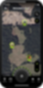
LAND OWNERSHIP
PUBLIC & PRIVATE
LAND OWNERSHIP
Nationwide Land Boundaries
Navigate public and private land boundaries
with our color coded parcel data set

TRUSTED BY OVER 1 MILLION HUNTERS
NAVIGATION
XDR NAVIGATION
Know the eXact Distance and Range
Easy point-and-go navigation with built in
COMPASS and RANGEFINDER

1 MEMBERSHIP FOR ALL 50 STATES
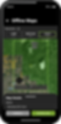
OFFLINE MAPS
HI-SPEED
OFFLINE MAPS
Trusted and Reliable Offline Maps
Use your phone's built-in GPS and navigate offline with our industry leading high-speed offline maps.
TRUSTED BY OVER 1 MILLION HUNTERS
LOCATION SHARING
LOCATION
SHARING
View the real-time location of your friends
Easily find your hunting partner if they need help packing meat or in the event of an emergency
*requires connectivity
1 MEMBERSHIP FOR ALL 50 STATES
SATELLITE IMAGERY
HI-RES IMAGERY
Study Terrain in Detail
E-scout, plan stand locations, and study terrain in greater detail with our high resolution satellite imagery

TRUSTED BY OVER 1 MILLION HUNTERS
GPS TRACKING
GPS TRACKING
Detailed Stats Wherever You Go
Make your way safely back to camp with
our detailed tracking tool.
1 MEMBERSHIP FOR ALL 50 STATES
MAP LAYERS
800+ MAP LAYERS
All the Overlays You Need for Success in the Field
Land ownership, hunting boundaries, wildfires, timbercuts, roads, trails, topography, lake depths, wilderness boundaries, roadless boundaries, and much more

TRUSTED BY OVER 1 MILLION HUNTERS


1 MEMBERSHIP FOR ALL 50 STATES


bottom of page